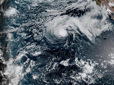
Open ocean storms often get dismissed if they don't slam directly into a coastline. That is a dangerous mistake. Hurricane Genevieve exploded into a powerful force over the Eastern Pacific, spinning hundreds of miles away from Mexico.
If you are tracking hurricane tracks or planning a coastal trip, don't let the "no direct threat to land" phrase fool you. Storms this size change the water around them entirely.
Tracking Genevieve on the Open Water
National Hurricane Center data shows Genevieve rapidly scaling up. What started as a modest system quickly morphed into a major hurricane churning off the southwestern coast of Mexico.
The system packed maximum sustained winds reaching up to 140 mph, earning it a dangerous Category 4 status on the Saffir-Simpson scale before expected mid-week weakening. Its core sat roughly hundreds of miles southwest of Manzanillo, chugging along on a west-northwest path at about 14 mph.
Because its track runs parallel to the shore rather than toward it, coastal towns avoided a direct strike. Evacuations weren't ordered. Landfall isn't on the table.
The Hidden Danger Hitting the Shoreline
Even when a hurricane stays out at sea, it acts like a giant paddle in a bathtub. Water moves.
Swells generated by Genevieve started battering the southwestern beaches of Mexico before marching north toward the southern tip of the Baja California Peninsula. Anyone ignoring the ocean conditions right now faces severe risks.
We are talking about life-threatening surf and ferocious rip currents. Beachgoers and local mariners often underestimate distant storms. They see blue skies overhead and assume the water is safe. That disconnect causes tragedies every single hurricane season.
What Else is Happening in the Pacific
Genevieve isn't working alone out in the vast ocean. Farther west, Hurricane Fausto has been tracking across the basin toward the Hawaiian Islands.
Fausto has slowly lost some of its punch, downgrading as it encounters cooler waters and less favorable atmospheric setups, but it still throws heavy surf toward Hawaii. Watching two simultaneous systems reminds us how active the basin gets during peak summer months.
Forecasters continue to monitor both paths closely. Check local advisory boards before heading out near the water. Respect the red flags on the sand. Stay out of the surf until the ocean settles down.