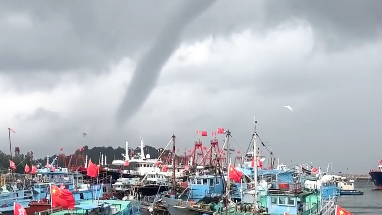
You think you know how a typical summer evening in Hong Kong plays out, then the sky drops a month's worth of drama in sixty minutes.
On Monday night, the Hong Kong Observatory triggered a sudden red rainstorm warning that sent commuters scrambling, turned parts of Wan Chai into temporary rivers, and sparked intense online debate over a mysterious swirling vortex off Cheung Chau. Then, just as quickly as the chaos started, the warning was stripped away. The entire red-alert cycle lasted exactly one hour, leaving residents looking at rapidly clearing streets and wondering what just happened.
This isn't just about a rainy night in July. It's a textbook example of how fast microclimates in the city can shift and why our assumptions about local weather alerts are often completely wrong.
The Hour of Chaos in Wan Chai and Cheung Chau
The timeline moved fast. The Observatory initially set an amber warning at 7:05 PM as a heavy weather system crept over the Pearl River Estuary. For a couple of hours, it felt like standard summer dampness.
Everything changed by 9:45 PM. The forecaster upgraded the status to a red rainstorm warning. Suddenly, the sky opened. In Wan Chai, localized downpours dumped water at a rate tracking over 70mm an hour. If you've ever walked down Queen's Road East during a severe cloudburst, you know exactly how fast the topography works against you. Water cascades down the steep slopes of the Mid-Levels, overwhelming roadside gullies and turning intersections into wading pools within minutes.
While urbanites dodged floods, people out on the islands were looking at a completely different spectacle. Around 6:36 PM, two residents on Cheung Chau captured footage of a massive, dark funnel cloud twisting violently over the water. The video quickly went viral, with localized social media channels lighting up over what looked like a textbook waterspout.
Timeline of the July 6 Storm Event:
6:36 PM — Suspected waterspout/funnel cloud filmed near Cheung Chau
7:05 PM — Amber Rainstorm Warning issued citywide
9:45 PM — Warning upgraded to Red; severe localized flooding hits Wan Chai
10:45 PM — Red warning cancelled; system rapidly moves out
The Observatory couldn't officially log it as a waterspout because the footage didn't clearly show the column making physical contact with the sea surface. Instead, they noted it as a prominent funnel cloud generated by intense thermal convection within the thunderstorm cell. Whether it touched the water or not, the visual was a stark reminder of the raw energy packed into these localized atmospheric disruptions.
The Fine Line Between a Tornado and a False Alarm
People often assume weather alerts apply evenly across the territory. They don't. The primary reason the red signal lasted only an hour, from 9:45 PM to 10:45 PM, comes down to how these aggressive convective systems operate.
An active southerly airstream, combined with localized upper-air disturbances, created a highly volatile pocket of air right over the urban core. The air heats up rapidly over the concrete jungle, rises fast, and meets cooler air layers above. This creates a vacuum effect. It triggers violent local vortices and drops immense volume over narrow corridors like Wan Chai while leaving places like Sha Tin relatively dry.
When that specific cell dumped its payload and swept northward into the mainland, the immediate threat evaporated. The Observatory had to pull the trigger on the red alert because the threshold for a red warning means rainfall exceeding 50mm an hour has fallen or is highly likely to continue generally across the territory. Because the system was hyper-localized and fast-moving, keeping the signal up would have been an over-correction.
What the Rest of the Week Looks Like
Don't pack away your umbrellas just yet. The unstable atmospheric pattern across the Guangdong coast means the city will face highly unpredictable, squally thunderstorms over the next 48 hours. Morning commutes on Tuesday and Wednesday are highly likely to face sudden downpours.
A massive weather shift is waiting at the end of the week. Tropical Cyclone Bavi is currently churning through the Northwest Pacific, tracking toward the seas east of Taiwan. While it won't hit Hong Kong directly, its outer subsiding air will act like a giant lid on the region's weather system. By Thursday afternoon, the rainbands will break up. Expect intense, dry heat to bake the city on Friday and Saturday, with temperatures easily soaring past the mid-30s.
How to Handle Sudden Urban Flooding
When a flash flood hits an area like Wan Chai, standing around on the sidewalk waiting for a taxi is a terrible strategy. Keep these quick operational steps in mind next time the sky turns black:
- Move high immediately: If you see water accumulating past your ankles on a sloped street, cross to the high side of the road or head inside a commercial building. Hong Kong's drainage systems catch up fast once the rain stops, but during the peak downpour, gravity turns roads into drainage channels.
- Check the radar, not just the signal: The Observatory app has a real-time rainfall radar map. Use it. If you see a dark red or purple patch sitting directly over your district, stay inside even if the official citywide signal is only amber.
- Avoid underground transit exits: Subway stations are engineered with flood barriers, but the immediate street-level exits in low-lying zones can experience severe pooling that makes exiting dangerous.
The reality of living in a coastal metropolis under the influence of changing tropical weather patterns is that one-hour red rainstorms are the new normal. Trust the data, watch the hillsides, and don't get caught arguing with a flash flood.