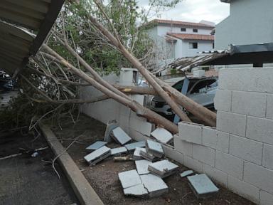
You don't expect Arizona weather to feature rotating supercells, shattered windshields, and tornado watches not seen in over a decade. Yet that's precisely what tore through the desert and mountain communities, leaving residents scrambling and meteorologists scrambling to explain a volatile atmospheric setup.
When a rare storm system barrels out of California, packing warm moist air and intense wind shear, the Grand Canyon State turns into a battleground of extreme elements. Let's look at what actually happened during these violent Arizona storms, why the setup was so unusual, and how communities are dealing with the fallout.
The Reality of the Storms
The numbers tell a chaotic story. National Weather Service offices issued 11 tornado warnings statewide during a single intense day, a staggering frequency for a region where tornadoes remain statistical anomalies. The last time the state saw widespread tornado watches of this caliber was back in October 2010.
In Navajo County, a likely tornado struck the community of Heber-Overgaard. It didn't just rattle nerves; it ripped through properties, brought down power lines, and caused at least one reported injury. Over at the Overgaard Baptist Church, members were wrapping up a Wednesday evening prayer meeting when the winds hit, stripping signs, shattering windows, and uprooting trees.
Meanwhile, places like Mesa and Flagstaff caught the brunt of destructive straight-line winds and ice. Wind gusts topped 72 miles per hour in some spots. Roofs took a beating, carports collapsed, and golf ball-sized hail cracked windshields and dented vehicles across multiple neighborhoods. In the Coconino National Forest northwest of Flagstaff, dozens of massive, thirty-foot ponderosa pines snapped like toothpicks. These weren't weak saplings. They were heavy, established trees felled by brute atmospheric force.
Why This Arizona Weather Event Defied the Norm
People unfamiliar with desert meteorology assume Arizona only deals with dry heat and the occasional summer monsoon. But autumn and spring transition systems bring entirely different threats.
Ryan Bernhart, a National Weather Service meteorologist based in Flagstaff, pointed out the exact mechanism driving the chaos. Warm, moist air surged northward, meeting cold energy sliding off the California coast. When you inject aggressive wind shear into that mix, the atmosphere starts to twist. That rotation is what spawns funnel clouds and sudden tornado risks in unexpected ZIP codes.
State Representative Walt Blackman didn't mince words after seeing the devastation in Heber-Overgaard, calling for immediate emergency coordination rather than waiting for slow bureaucratic damage tallies. Families were left without power, homes suffered structural hits, and local emergency crews had to navigate blocked streets cluttered with massive tree limbs and downed utility poles.
What to Watch for Next
While the immediate tornado threat eased as the system shifted, the danger didn't vanish entirely. Meteorologists like Mark O'Malley at the NWS office in Phoenix warned that heavy rainfall and flash flooding remained major hazards for metropolitan areas and low-lying desert washes.
If you live in regions prone to sudden weather shifts, you know that preparation makes all the difference. Keep your emergency alerts active, move vehicles away from vulnerable trees if a severe cell approaches, and never drive across flooded desert roads where a few inches of moving water can sweep a car away. Stay alert and take warnings seriously the next time the desert skies turn dark.